October 14, 2000 St. Elmo, IL Written and Read by Penny V. Lewis(Fayette County, IL GenWeb Coordinator) for National Road Ribbon Cutting Ceremony How Did the Road Get Started?
It was not until 1802, President Jefferson's
Secretary of the Treasury, Albert Gallatin, proposed a plan that sparked
interest, known as the "Origin of the National Road". The plan allocated
money from land sales, allowing a percentage to be used for the making
of the first federally funded highway.
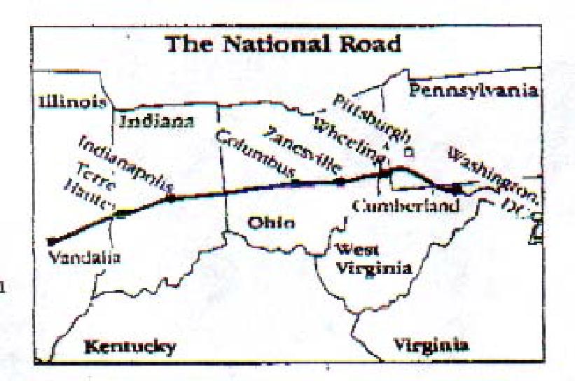
The Building of the Great Road West Even though, contracts were not granted until 1811, road construction did not begin until 1815 in Cumberland, Maryland and reached Wheeling, Virginia (now West Virginia) in 1818, being delayed because of the war of 1812. From Wheeling, Ohio was only a bridge length away. Many families preferred to migrate by Ohio River boats than by slow wagon journey westward through the wilderness of deep ruts and low lying stumps. The terrain varied from state to state as well as the quality of bridges and roads. Original specifications for the road were used before the utilization of Macadamization. This rather expensive and sophisticated engineering technique used layers of stone to build the road. To make the road, the ground would have to be dug 12-18 inches deep and stones approximately 7 inches in diameter were used for the base. Then smaller stones that passed through a three-inch ring and graded down. Macadamization was the ideal surface for the time, but due to the expense it was not available everywhere. Plank roads, literally building of a floor of timber as a roadway, was used and look upon as a perfect answer to providing smooth, dust-free roads in muddy rural areas. Over time, deteriation was common among these timber highways and plank roads were not used everywhere. By 1820, money
was appropriated to survey the remainder of the states: Ohio, Indiana and
Illinois. Road building was a huge task. And a variety of skills were needed.
Surveyors laid out paths; engineers oversaw construction. Masons cut and
worked the stone, and carpenters framed bridges. Numerous laborers pulled
and tugged, cut and hauled and leveled to clear the path. By 1822, President
James Monroe vetoed a proposed legislation to turn the National Road into
a federal toll road. Ownership of the road was handed to the states through
which the road passed. The states built tollhouses along the road to collect
tolls to help fund repairs needed for the road.
FAYETTE COUNTY, ILLINOIS AND THE NATIONAL ROAD In 1828, a surveyor named Joseph Shriver surveyed the eighty-nine mile route from Indiana to Vandalia, IL. Many hardships endured during his survey in July of that year. He recorded a few of these in his survey notes: "Saturday, July 19th, 1828
Sunday, July 20th, 1828
Monday July 21 st, 1828
It was not long after Shriver's Surveys, Congress
appropriated $40,000 in 1830 to open the Illinois section of the road.
Later, additional money was granted each year for the much needed work
of clearing land, grading and the bridge building work. New towns
began to spring up over night along the route. Many businesses began to
set up shop along the road to accommodate the needs of the workers of the
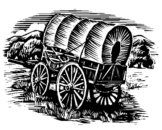
National Road. Huge Conestoga Wagons came in droves, traveling the dusty
road westward.
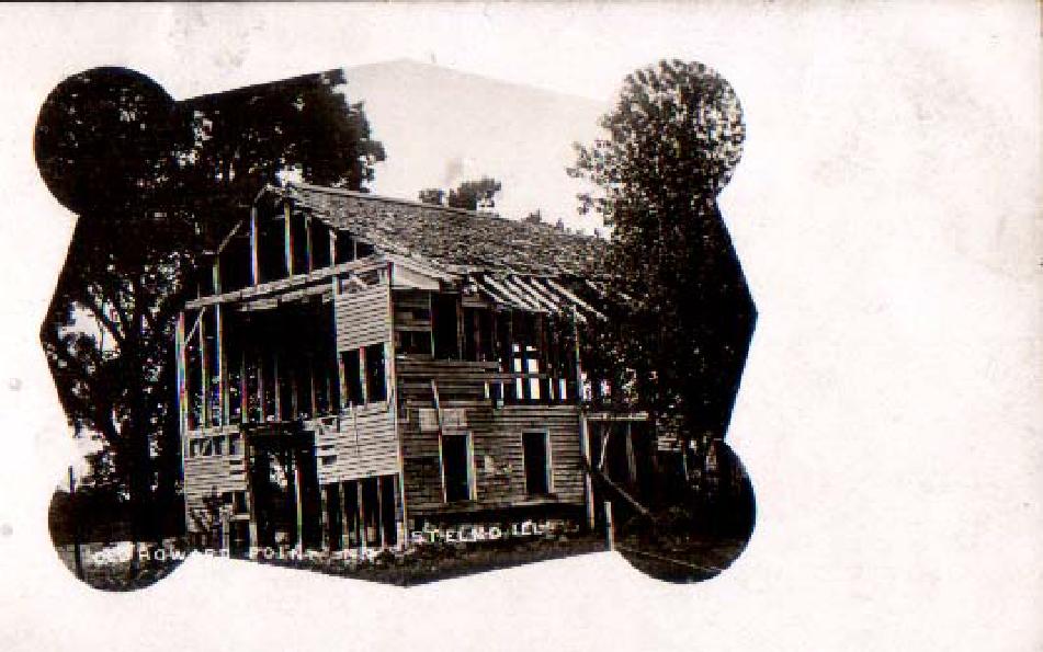
What does the National Road Have to Do with Howard's Point or St. Elmo? Two men named George and Wiley Howard settled at Howard's Point in 1834 during the construction of the National Road. The Howard's Point settlement was located at section 27 of Howard's Township, next to the Sugar Creek. It is better known today as Avena Township on the west edge of St. Elmo. A perfect location to supply the small settlement with all their needs of vast timbers, good soil and a waterway.
Soon a store, referred to in those days as a "tippling house", was opened at Howard's Point in 1834 by proprietor B.F. Simons. To accommodate the workers of the National Road, Simons sold food items, merchandise and liquor. Henry C. Waterman opened the first "tavern" a term used in those days to refer to an "inn" or "a place for lodging". In 1837, Waterman soon established the first post office at Howard's Point and established several stage lines running U.S. mail in every direction. A need for a physician became apparent with the rapid growth of the community. Dr. George Halbrook was the first practicing physician in the township. His practice often extended twenty to twenty five miles, traveling on horseback on the account of the roads being so bad. Many times, his patients were without money and he often was compensated with produce or coonskins for his services, if any at all. Nicholas Helm saw the need for a mill and built the first sawmill at Howard's Point. Soon a blacksmith was needed and a school. William Smith taught school in an old dwelling house for many years in the small settlement. It was not long before Howard's Point became a village. In Fayette County, Howard's Point was the first settlement that awaited travelers when following the National Road west to their designation. Many families placed their home here after seeing a thriving village. We can be certain of the importance of this village, stemmed from the westward expansion and the National Road. It was not until almost a half of a century later, in 1869 that many businesses and families left Howard's point, to built homes and established residence east of Howard's Point, in what is known today as St. Elmo. In 1838 the road had finally reached its end to Vandalia, Illinois, the current state capital at that time. During the summer of 1839 the National Road was open for travel in Illinois. Although the road was surveyed to Jefferson City, Missouri, construction was halted at Vandalia, Illinois. Due to lack of funding by the government and squabbling over the route for which the road would take. Missouri wanted the road to travel through St. Louis, MO and Illinois wanting it to travel through Alton, Illinois, a town located along the Mississippi River. After a total of 600 miles and approximately $7,000,000 the road to the wilderness was completed. Over time, railroads and eventually the use of the automobile had replaced the old road as major arteries of transportation. In 1926 the road was changed to US Route 40. But for the most part, whether it was huge Conestoga wagons used to haul produce from the farms to the east coast for the exchange of manufactured goods, or the stage coaches that traveled regular scheduled routes to deliver mail, or the thousands of families that braved the wilderness and fought the road to move westward with their hopes and dreams of prosperity and a greater life beyond a vast wilderness, our National Road was by far the most traveled road. It can be for certain, that this road is truly "America's first highway." Written by Penny V. Lewis lewis@papadocs.com
Brusca, Frank. "History of the National Road and U. S. 40." Route 40
Website. <http://www.route40.net/history/history.htm>
For more information visit:
© 1997, 1998, 1999, 2000, 2001 Fayette Co., IL GenWeb Project.  All
Rights Reserved. All
Rights Reserved.
The electronic pages on this website are not to be linked to or reproduced in any format for profit or payment. They may be freely used by non-commercial entities This page is part of the US GenWeb Project & IL GenWeb Project. In keeping with our policy of providing free information on the Internet, data and images maybe used by non-commercial entities, for educational and/or research purposes as long as no payment is asked for or made in exchange for viewing them and this message remains them. These electronic pages cannot be reproduced in any format for profit or for other presentation without express permission by the contributor(s), Fayette County GenWeb Project, Illinois GenWeb Project and US GenWeb Project. |